
The Incas in Arica – Ancient Monuments and the Lauca National Park
The Region of Arica and Parinacota was once territory of the Inca, settled by Aymaras, Chinchorros, Changos and Quechuas.
In the pre-columbic epoch the messengers of the Inca, called Chasquis, travelled very fast between the Tambos (constructions that were used as accommodation, resting place, storage for wool and food and a place to wait for new messages), that were located between the National Park Lauca and Arica. The Chasquis travelled frequently to the KapajÑam (today known as the Way of the Inca “El Camino del Inca”), and on their way they stopped at the Tambos on the way to rest before they continued their journey to deliver their messages.
Because the Incas didn’t use a modern system to measure distances, they created markers out of stones on the way, so called Apachetas, that indicated the most important places on the route. In the course of time the cultural hybridization in the region began and they added garlands and cruces to the Apachetas that show the Spanish influence.
Discover the heritages and the architecture in the region
On the way that connects Arica with the National Park Lauca you will find a high number of monuments of the Inca, some of which are nine or more centuries old:
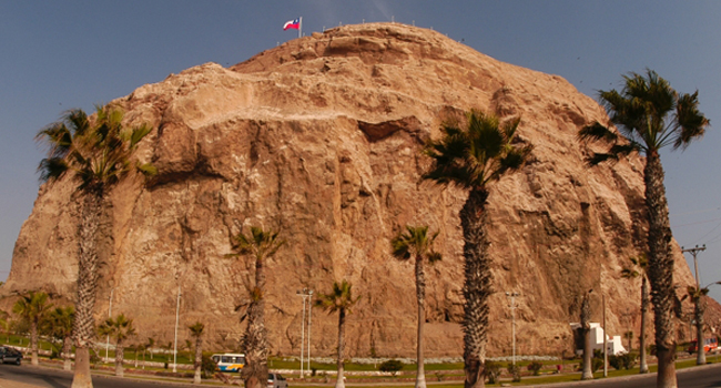
The Morro of Arica, called Ariaka (“entry door”) in the language of the Aymara. It is located in the center of the coastal city of Arica, close to the harbor. The Morro was of high signification in the Pacific War, after the battle of Arica on July 7th 1880, when Chile took over Arica. This huge rock was settled by natives, called Morreros, until the Spanish invaded Chile.
Some of the oldest myths of Arica are about the Morro, for example the story of the Inca caves. According to the information archived in 1825, George Taylor, investigator and inhabitant of Arica, discovered a cave of 1600 meter of depth and a salt lake inside.
“The Morro of Arica was declared National Monument on October 6th of 1971”
The Tambo of Zapahuira, called ZapaJawira (“single river”) in the language of the Aymara. It is located about 50km of Arica and is an excellent example of the architecture of an ancient inca-tambo. It was declared National Monument in 1983.
Waka: Chullpas Funerarias (Andean monuments to honor the dead) were constructed in the 13th century a.C. and are to find in the surroundings of the Tambo of Zapahuira.
The fort of Copaquilla, called Qupaquilla (“golden Moon”) in the language of the Quechua. It is located 75km of Arica in the commune of Putre, also called Putire in the language of the Aymara (“torrential water”). This fort was constructed in the 12th century a.C. at a height of 3000 meters and was declared National Monument in 1983.
How to get there
Arica is located 18km south of the Airport Chacalluta. Travel 5km north of Arica to the international Route 11-Ch which follows the river Lluta and leads to the Lauca National Park, located 140km east. On this route you will see the Tambo Zapahuira, the Chullpas and the fort of Copaquilla.